
Map Cabinet
Welcome to the City of Waltham's Map Cabinet. The Map Cabinet allows users to download select city maps in PDF format free of charge. We will be continually updating our inventory of downloadable maps so please check back frequently for new maps and updates. The GIS group can print copies of the maps upon request for a fee. If you would like to request printed copies of these maps please click here.
| Map | Description |
|---|---|
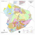 | Zoning Map Map showing zoning districts, Riverfront Overlay Districts, and Limited Commercial Revitalization Area Overlay District. Map Size: 30" x 30" |
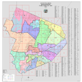 | 2022 Ward & Precinct Map - Updated, March 31, 2022 Updated Ward & Precinct map showing wards and precincts in Waltham after 2021 redistricting. Map Size: 32" x 32" |
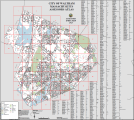
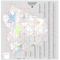 | Street Map with Index Street map showing all streets within Waltham. Map Size: 30" x 30" |
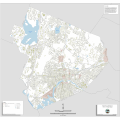 | Historical Resource Map Map showing historic districts in Waltham. Map Size: 30" x 30" |
 | New! Parcel Atlas with Index Atlas showing all tax parcels within Waltham. Map Size 27" x 30"
|