
Wetlands Mapping
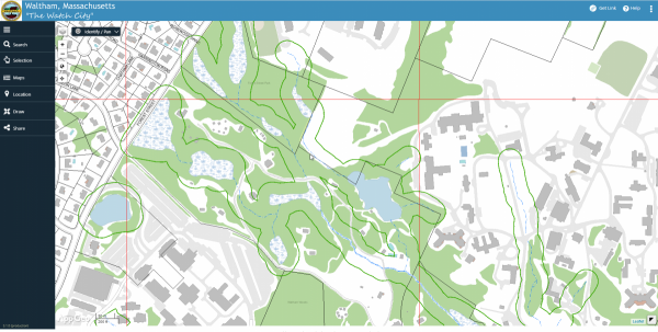
This map shows the approximate jurisdictional limits of the Waltham Conservation Commission under M.G.L. c. 131, § 40: The Wetlands Protection Act (WPA) and 310 CMR 10.00 regulations. The limits shown (green line) are a composite of Bordering Land Subject to Flooding (approximated as FEMA flood zone), 100 ft. wetland buffer zone (based on offset from MassDEP GIS Wetlands layer, which was generated by analysis of aerial photographs), and 200 ft. riverfront areas. The map also includes manual updates by Waltham staff to a variety of locations based on field observations by commission members, prior maps, aerial photographs, and resource area delineations submitted by wetland scientists and accepted by the Commission. This tool is provided as a convenience for rapid screening of whether a location is likely to be in WPA jurisdiction. In the case of an ANRAD or NOI filing, exact limits of jurisdictional areas shall be identified on site by the applicant as required by 310 CMR 10.00.
Disclaimer:
The City of Waltham does not make any warranty, expressed or implied, nor assume any legal liability or responsibility for the accuracy, completeness, or usefulness of the Geographic Information System data provided herein. The data do not take the place of a professional survey and have no legal bearing on the true shape, size, location, or existence of a geographic feature, property line, or political representation. The City of Waltham requests that any use of this information be accompanied by a reference to its source and the City of Waltham’s caveat that it makes no warranties or representations as to the accuracy of said information. Any use of this information is at the recipient’s own risk.
| Search By Address | Go Directly to Map |